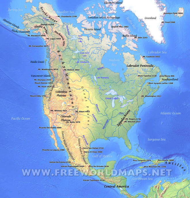
The vast majority of North America is on the North American Plate. Parts of California and western Mexico form the partial edge of the Pacific Plate, with the two plates meeting along the San Andreas fault.
The continent can be divided into four great regions (each of which contains many sub-regions): the Great Plains stretching from the Gulf of Mexico to the Canadian Arctic; the geologically young, mountainous west, including the Rocky Mountains, the Great Basin, California and Alaska; the raised but relatively flat plateau of the Canadian Shield in the northeast; and the varied eastern region, which includes the Appalachian Mountains, the coastal plain along the Atlantic seaboard, and the Florida peninsula. Mexico, with its long plateaus and cordilleras, falls largely in the western region, although the eastern coastal plain does extend south along the Gulf.
Lakes of North America:
Lake Winnipeg, Great Lakes, Great Bear Lake, Great Slave Lake, Lake Athabasca
Rivers of North America:
Mississippi, Missouri, Yukon, Río Grande, Arkansas, Ohio, Mackenzie, Nelson
Mountains, plains, regions:
Central America, Appalachians, Colorado Plateau, Rocky Mountains, Mackenzie Mountains, Brooks Range, Alaska Range, Labrador Peninsula, Cascade Range, Columbia Plateau, Great Plains, Sierra Madre Occidental, Sierra Madre Oriental
Islands and peninsulas:
Antilles, Greenland, Vancouver Island, Haida Gwaii, Newfoundland, Canadian Arctic Archipelago, Ellesmere Island, Baffin Island, Victoria Island, Aleutian Islands, Alaska Peninsula
Highest peaks of North America (with elevation):
Picacho Del Diablo 3069, Sierra El Viejo 3500, Picacho La Laguna 1980, Mont Jacques-cartier 1268, Mt. Caubvick 1652, Gros Morne 806, Mont Yapeitso 1128, Volcán De Colima 4330, Pico De Orizaba 5636, Volcán Popocatpetl 5420, Mt. Baldy 3476, Mt. Robson 3954, Mt. Waddington 4019, Mt. Olympus 2429, Mt. Fairweather 4671, Mt. Logan 5959, Mt. Blackburn 4996, Mt. Elbert 4402, Mt. Mitchell 2037, Mt. Rogers 1746, Mt. Washington 1917, Mt. Hood 3426, Mt. Chamberlin 2749, Mt. Whitney 4421, Mount Rainier 4392, Mount Eddy 2751, Cerro San Rafael 3710, Mt. Odin 2143, Qiajivik Mtn. 1963, Volcán Tajumulco 4220, Gunnbjørn Fjeld 3694, Mt. Forel 3360, Pico Duarte 3098, Pico Turquino 1974, Blue Mountain Pk. 2256, Denali 6194
Oceans, seas, bays:
Hudson Bay, Labrador Sea, Beaufort Sea, Baffin Bay, Caribbean Sea, Sargasso Sea, Bering Sea, Gulf of Mexico, Atlantic Ocean, Pacific Ocean

Geographical map of North America
Click on above map to view higher resolution image

Could not find what you're looking for? Need a special North America map? We can create the map for you!
Crop a region, add/remove features, change shape, different projections, adjust colors, even add your locations!